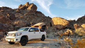
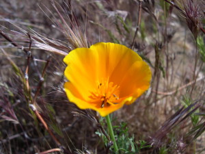
If you’ve been watching or reading the news in California recently you’ve probably been hearing about the “superbloom” that’s happening in Death Valley National Park. Although some of the stories out there are boasting that this is a once in a lifetime occurrence, it actually happens whenever the particular conditions are right. The last superbloom was in 2005 when that seasons rain and weather cooperated to result in an explosion of wildflowers throughout the park. This years El Niño brought the kind of soaking rains that were needed for the wildflower seeds to germinate and reports started coming in that a superbloom was beginning. Checking out the weather reports for the Valley showed highs in the low 80’s and clear weather for the weekend so I packed up some gear and my family to go check it out for ourselves!
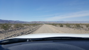
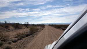
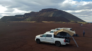
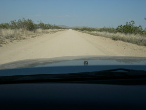
Checking the Death Valley Road Conditions Facebook page told me that the 178 was closed between Shoshone and Jubilee Pass effectively closing off the only paved road coming up from the south of the park, exactly where we want to go… Luckily there is an option. Harry Wade Exit Route, a narrow and rough dirt road that follows the route that Harry Wade and his family found while escaping Death Valley and the ill fated 1849 caravan that found themselves lost in the Valley. Traveling along the southern border of the park before heading up the Amaragosa River valley joining Badwater Road just south of Ashford Mill. This is exactly where we want to be!
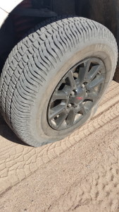
Just a quick word about the Harry Wade, although it is deceptively tame looking, this road is not for the unprepared. I’ve traveled this road many times and I’ve seen Jeeps, Landcruisers, and Subarus driving along, happy as can be… But I’ve also seen some Hondas, a few Priuses and now a rented Hyundai Sonata driving down this road. They may have made it through safely and they were either lucky or just good experienced drivers. I can tell you that this road likes to eat people’s tires and it struck again on this trip, taking out my front drivers side tire… not just once but twice on the same trip! Yeah, these are the stock tires but the Michelin LTX AT2 tires have worked great for 12,000 miles and on two Mojave desert and one big Utah National Park tour that included lots of off-road and even driving over quite of bit of really rough lava rock on our last excursion. Just be prepared, this area can be harsh on the dumb and the unprepared…
Harry Wade Exit Route
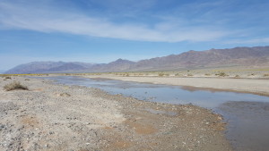
Saratoga Springs
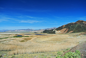
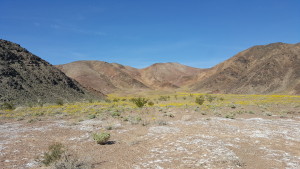
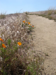
Our first stop is Saratoga Springs, a truly unique and surprising site found in this remote part of the Park. The sight of deep blue water and the deep green vegetation of this riparian wetland in the midst of the desert, nestled against the striking colorful Ibex Hills is just an example of the contrasts that are found in the Park. Although the area around the springs is very dry we find nice pockets of flowers in the area that whets our appetite for more!
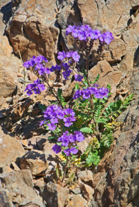
Blue Phacelia
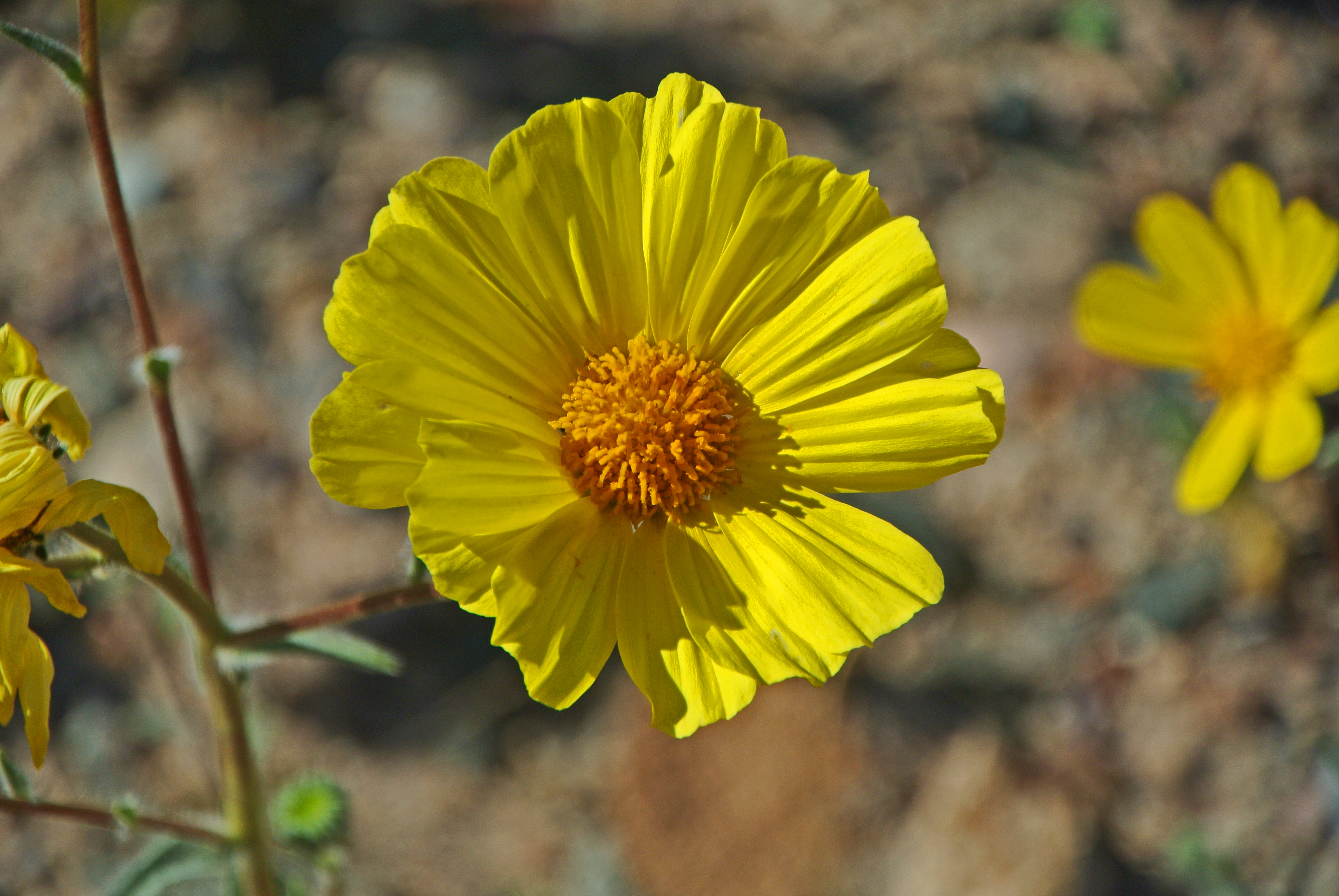
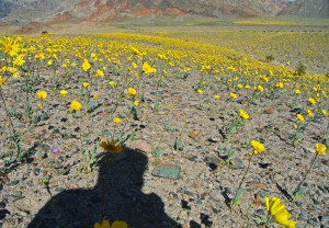
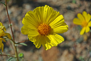
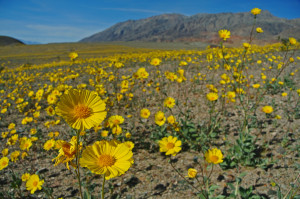
Fields of Desert Gold
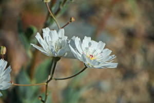
Gravel Ghost
Amaragosa River
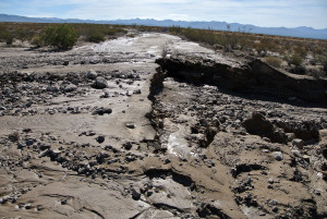
After crossing the usually dry Amaragosa River, the low tire pressure gauge came on. I decided to try to make it to Badwater Road and after getting to the pavement I pulled off to evaluate the tire. Luckily I keep a CO2 bottle to refill my tires on the truck. I almost left it at home for this trip! I found the leak and started trying to plug the leak, four plugs and half a can of fix-a-flat later we had pressure and we pushed on…
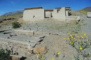
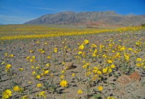
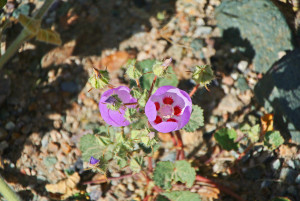
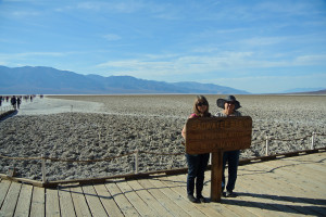
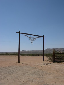
Ashford Mill was our destination and this area did not disappoint with the display! Desert Sunflowers, Desert Five Spots, Blue Phacelia, Sand Verbena and Gravel Ghost were all abundant but the Desert Sunflowers stole the show. Looking in all directions you could see the bright yellow flowers dominate the landscape. It was impossible to properly capture the scene and so far I haven’t seen any pictures that do it justice. Although not as impressive as displays we’ve seen up the coast or even down in Anza-Borrego but for the sheer quantity of flowers, this was a powerful display.
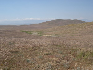
After basking the glory of the flowers for awhile, we decide that since neither my sister or mom had ever been to Death Valley, we should make the drive up to see Badwater and Artists Palette. There were a lot of people in the parks, no doubt here to see the superbloom for themsleves. We were surprised to see that the wildflowers were very sparse around the Furnance Creek area and it shows that the rains that came this winter were sporadic. Furnace Creek received only about an inch and a half of rain, whereas typically we need about five inches for the wildflower seeds to germinate. Obviously further south they received more rain so it’ll be interesting to see once the bloom moves up the park how other areas will do.
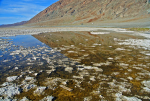
bad water… bad… too salty!
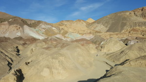
Badwater Basin
Artists Palette
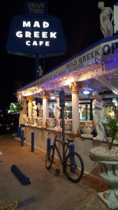
We made a quick stop at the two locations and it was already 4PM and we still needed to get back down the Harry Wade and back home! So I checked tire pressure one last time and we headed home, along the way we got to see the flowers in the fading evening light and the sunset over the Valley. We hit the Harry Wade with just a little sunlight left and knew we would be in the dark by the time we hit the pavement on the 127. About 20 miles out from Baker the tire pressure light went on again, this time I knew that tire was dead. I drove along carefully as long as I could and pulled over where there was a decent room and a straight portion of road so other cars could see me. I pulled out two hi-intensity chemical lights and threw them out on the roadside for a little warning and clicked on the hazards. Remember, changing a tire on the side of the road is very serious business and can be extremely dangerous. You need to watch out for traffic and never turn away from oncoming vehicles. I had a very capable helper in my wife and she’s the head flashlight holder (and I had several flashlights available, for backstory on why click here…) Anyway, long story short I get my full-size spare installed and filled with air. Cleaned up my tools, gloves, jack and tire and we are on our way again in less than an hour total. My reward? The Mad Greek, of course! So our adventure ends where it began, excpet this time I have a peanut butter milkshake in my hands when we leave. If you are ever in the area, do yourself a favor and have a milkshake… they are delicious!
For the rest of my pictures from this adventure please see my Flickr account here…
With friends visiting from out of town, wanting to experience the solitude and peaceful beauty of the desert, we had planned an epic trip through Death Valley. Rhyolite, Titus Canyon, Scotty’s Castle, Ubehebe Crater, Racetrack Playa and then down through the valley proper to visit Badwater, Natural Bridge, West Side Road and finally out through the Harry Wade Escape Route… all for naught as the biggest storm to hit in centuries slammed into the park closing down the entire park. People got stranded all over the park and tales of unbelievable storm damage started trickling out. There we were, in Las Vegas… North Las Vegas at that… on Fremont Street… the exact opposite of solitude and peaceful beauty… what to do? Well, here is where our adventure begins!
We are staying at the Downtown Grand which was recently remodeled and very inexpensive and since we were meeting up with some friends that were on their way back from Yellowstone National Park it seemed like a good spot close the freeway. the hotel overall was nice and for the price its hard to complain but there were two things that will keep me from returning; 1) the noise coming from Fremont Street was pretty intrusive, now for some who are here for things other than getting a good nights sleep so you can go wandering through the desert the next morning it may be acceptable but for us it was difficult to drown out… 2) the showers have no doors, or curtains… just this half glass wall thing that is just plain stupid, EVERYTHING in the bathroom gets splashed. I realize I’m paying only $40 a night but hey, can I get a curtain please?? Okay, rant over… let’s find some food!
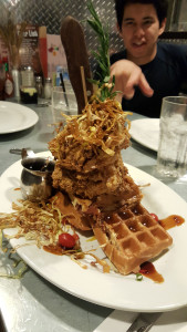
We need to get some grub so we look up what’s close by and remember that our good friends Shaun and Bobby had eaten at a place close by. This is Hash House a GoGo and their Sage Fried Chicken and Waffles. Our friend Kevin is pointing out the unbelieveable portions that are served here in the States and that people just cannot believe that Americans eat so much! This could easily feed two or more and it was very tasty, although the serving size was a little over the top. We discussed options for the morning and decided that we’ll regroup in the morning after gassing up and figure out where to go. Everyone had a great attitude about the weather and we figured to stay flexible about where we go.
So the next morning, after some coffee and listening to weather reports and traffic reports we finally make the call that we have to give up trying to get into Death Valley. The northern route through Beatty was closed entirely and the road that drops in from the Bonnie Claire got completely wiped out. the southern routes through Baker remain open only to Ashford Mill and so the entire park was getting shut down as the rangers went out and made damage assessments. I made the call that we should head into the Mojave Preserve instead, that although they may have gotten hit by some bad storms, they rarely close roads and we would at least have a chance at finding a campsite and some interesting things to do. With that we all jumped into our trucks and headed south into Primm to gas up. The plan was to jump onto the Union Pacific service road at Primm and head down the Nipton-Desert Road to Nipton and then head into the Preserve at Ivanpah siding, visit Goldome Mine, Rock Springs and head down Black Canyon Road to find a campsite.
Hey, this looks pretty good… not even that wet!
Oops, spoke too soon!
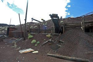
I’ve been driving down this service road and the connected Nipton-Desert Road for years and I’ve never seen it this badly damaged. Huge washouts, mud flows and standing water all along the route. It made for a mildly exciting drive with only one real washout that I needed to get out and survey before we crossed. But soon enough we reached Ivanpah siding and we headed up into the hills towards Goldome Mine. Only recently abandoned in the 1980’s this place was very well preserved when we first visited a couple of years back but now it seems that people are vandalizing the place. We spent awhile here exploring the place and burning off a little extra energy from the long drive but soon we wanted to find a nice place to make some lunch so we pushed onward.
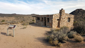
Down Lanfair Road and then over on Cedar Canyon Drive which parallels the Old Mojave Road as it passes through this area, near to where the two intersect is Rock Springs and Burt Smith’s cabin. Here under an old juniper tree is a picnic table with a great expansive view of the surrounding desert. we stopped here to make lunch and make use of the vault toilet that the National Park Service installed a few years ago.
Bert George Smith was a World War I veteran, who suffered the effects of shell shock and was a victim of poison gas. The Bureau of Veterans Affairs sent him to live in the desert with the hopes that he would live a longer life, due to the dry climate. He built this cabin in 1929, originally as a wood framed building adding the stone in later years. Despite his short life expectancy, Smith lived at his cabin at Rock Springs until the mid-1950s. He eventually died ina rest home in 1967. There is a trail behind the house that leads over to the springs, it’s a short hike but worthwhile to see a desert spring.
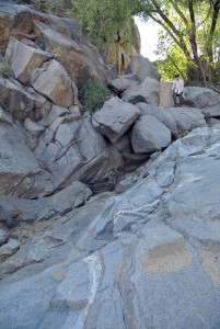
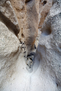
Rock Springs is one in a series of springs that dot the Mojave Desert every 20 to 30 miles, forming a natural travel corridor. This route eventually became known as the Mojave Road. Native Americans from the desert regions around the Coloroado River used this corridor to trade with coastal tribes and later ranchers used it to water thier livestock. In the picture above you can see a dam was built to provide a little extra storage behind it. Today the spring was completely choked out by sand, the deep pools I had seen in the past were completely filled in. Most likely the large storms that passed over the area brought the sand and silt down from the upper basin and filled in the pools. It will take another storm or two to eventually wash out the sediment again.
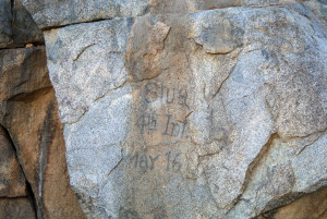
The upper inscription appears to be from the time when the US Army had an encampment here called Camp Rock Springs. Brigadier General James T. Rusling described the encampment in 1866, “Camp Rock Springs itself was a forlorn military post, consisting of one officer and perhaps a dozen men, guarding the springs and the road there. The officer was quartered in a natural cave on the hillside, and his men had ‘hutted’ themselves out on the sand the best the we could”. It was most likely a member of the 4th Infantry Regiment of California Volunteers, “Stuart” probably carved this between 1863 and 1866 when that regiment provided many of the troops to protect the Government Road. Records show at least one Stuart in that regiment during that period.
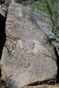
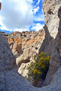
There is evidence of earlier use of these springs as well, in the form of petroglyphs carved into the rocks. Many of these petroglyphs are very faint, indicating they are very old with the abstract style on the lower portion of the rock likely by the local Chemehuevi tribes related to the Southern Paiute Indians and the upper portion with the nonrepresentational geometric designs from a Mohave Culture indigenous to the Colorado River area and related to the Kumeyaay Indians from the south.
After hiking and spending some time around Rock Springs we headed down the Mojave Road to where it intersects with Black Canyon Road. From here we turn south and drive though the Mid-Hills area and pass by Hole in the Wall where we find our campground, just south of that area in a small turnaround above a small wash I call, Bachelor Wash in honor of our friend, David who spent his bachelor trip camped out in that very wash. Secluded and with a spectacular backdrop we setup camp and settle in for the night. As the stars begin to appear overhead we begin to think, maybe this change of plans wasn’t so bad after all!
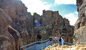
The next morning we break camp and head over the Hole in the Wall to use the facilities and stretch our legs. Part of the group continued down the Rings trail while the rest of us hung out at the overlook.
Follow the sign for the Rings Trail down a few boulders into a narrow canyon. Here there are two dry falls on the descent into Banshee Canyon, named for the crying sound that the wind make as it blows through the rock formations. There are two sets of rock-mounted ringbolts which can be used as hand holds and steps to get down to the bottom of Banshee Canyon. This opening quarter mile stretch is the most exciting and many hikers simply turn around at the bottom of the canyon and hike back up over the rings for a 0.5-mile round trip hike. Otherwise, follow the path out the mouth of Banshee Canyon and turn left continuing along the Rings Trail as it wraps around the south side of a rock wall on a gradual course to a trailhead that returns to the Visitor Center.
group shot at Hole in the Wall
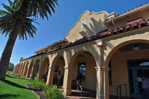
After our hike we feel like eating some lunch and we want to stop by Kelso Depot to see if the lunch counter there is open. The Kelso Depot was constructed in 1924 and included a conductor’s room, telegraph office, baggage room, dormitory rooms for staff, boarding rooms for railroad crewmen, a billiard room, library and locker room. The closing of the nearby Vulcan mine which employed over 2,000 and the use of diesel engines replacing steam resulted in the Union Pacific moving jobs and families out of Kelso. The depot function ended in 1962, although the restaurant and boarding rooms were still in use. The advancement of diesel technology led to fewer and fewer crew members needing to eat or stay overnight, so in 1985 the Union Pacific decided to close the Kelso Depot entirely.
After many years of being unused the Depot was passed into the hands of the National Park Service upon formation of the Mojave National Preserve. The building reopened to the public as the new visitor center for Mojave National Preserve in October, 2005. Former dormitory rooms contain exhibits describing the cultural and natural history of the surrounding desert. The baggage room, ticket office, and two other dormitory rooms have been historically furnished to illustrate life in the depot in the first half of the twentieth century. Downstairs, the Desert Light Gallery features rotating fine art collections by local artists, focusing on the cultural history and natural splendors of Mojave national Preserve.
The Kelso Depot lunch counter, named The Beanery recreates the original lunch counter that was here in the 20’s and 30’s where you can enjoy a hot cup of coffee, cold ice cream, or a deli sandwich in this nicely restored and historic train depot. Unfortunately for us the Depot was closed that day due to some budget cuts and shortage in staff. If you are visiting, check their website for the current schedule. We hung out here, again to use the facilities (see a common theme here?) and then headed off to the Kelso Dunes for a quick hike!
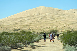
The Kelso Dunes cover 45 square miles of desert with the tallest dunes over 650 feet. While a few if us hiked only to the base of the dunes, a couple went to the top. While they were up there the group on the bottom heard the booming noise that these dunes are famous for. The noise is caused by the sand sliding down the dunes. Only a few dunes on earth are capable of making this sound and we were lucky enough to actually hear it. I kept my eye on the impressive clouds that kept rolling past us as I didn’t want to get caught out in the open if a lightning storm decided to pay us a visit.
I kept my eye on the impressive clouds that kept rolling past us as I didn’t want to get caught out in the open if a lightning storm decided to pay us a visit. We were fortunate on this trip that the weather cooperated nicely and we didn’t experience any rain or high winds that are pretty common here.
We didn’t get any pictures of the ascent to the top of the mine but it was epic. Getting stuck several times in the deepy rutted and very loose rocky soils it took a lot of time to get up to the top. The Tundra? It walked straight up without any drama or problems.. and Irene was driving! I got out to spot on some tricky areas but she got the truck to the top without much trouble. Kevin’s full size Chevy hit a couple of snags but once in 4 low it got to the top just fine. Mark’s Tacoma… my old truck had some trouble. Getting high centered on the deeply rutted road once and then getting hung up on the spare tire mounted under the bed. Once we got it loose I offered my driving experience and got it up the toughest parts of the road. The one lesson I had was, “if in doubt, throttle it out!” The cinder cone surface of the rocks certainly was not kind to the older BFG Mud Terrains on the truck but without those and the rear lockers it never would have made it up. I gotta say, I still love that Tacoma, it still has been able to follow any 4wd anywhere!
The Aiken Cinder Mine was abruptly shut down and abandoned in the 1990’s when the operators could no longer pay rent on the property. Millions of tons of cinder rock was mined from this ancient volcano and most of it is still in piles around where we camped for the night. The rest was shipped to a company in Las Vegas as road construction material. Although no remediation is planned for this area I noticed that more and more of it is missing everytime I go. Sooner or later this will start to return to a more wild naturalized state and most of the machinery and equipment will just rot away. The piles of mined cinder rock provided a nice sheltered area for our campsite and now I can say that my Tundra has been to the top of a volcano! Just like in the commercials!
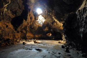
The Mojave Lava Tube was our last stop of the trip and it is one of the most unique places to visit in the Mojave. Formed by flowing lava where the surface has hardened and cooled while the interior of the lava continues to flow leaving a hollow tunnel in its place. When we first found the lava tube there were no directions or even signs at the time. The nice landing and stairs weren’t there, just an old rusted ladder. Not much of a hike and the road leading is well graded dirt. This time was a little different as well with fresh mud flows coating the ground of the tube. It looked like a pretty good flow of water was in the tube recently and uncovered some interesting skeletal remains of local desert dwellers like rabbits and lizards. I really wanted to revisit another site in the nearby Black Tank Wash where a lava arch had formed due to the collapse and erosion of an old lava tube but the road was so rough due to washouts we decided it better to end our trip here.
So we head out of the Preserve on Kelbaker Road and head back to civilization. It wasn’t the trip I planned but overall it was a good trip, although I’ve never had a bad trip out to the desert to explore. We got to share some of the reasons why I love this area so much and why I spend so much time exploring out here. So until next time, wander and explore and find your adventure!
So I’ve had my truck now for about a year but I have been so busy with my new job that I never had the chance to really take my truck out and try it out offroad. I had recently purchased a backroads guidebook, Backcountry Adventures by Peter Massey, and was looking at several options. One in particular that intrigued me was Calico Ghost Town and the remote Daggett Wash area that passes through the Ord Mountains. I couldn’t find very much information on this route online and the Backcountry Adventures book rated it as a 3 in difficulty so I was interested in seeing this area for myself.
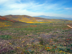
The previous year had been awesome for wildflowers and our trip to the Antelope Valley California Poppy Reserve SNR was very memorable and Irene’s mom after seeing the pictures of our trip really wanted to go see the Reserve. Armed with a copy of Delorme’s Atlas and Gazetteer we headed out towards Lancaster with plans to see the Reserve with her parents and then Irene and I would go exploring on our own.
On our way to the Reserve we noticed wild poppies growing in the median of Highway 14 so our hopes were high but when we arrived at the Reserve we could tell that the bloom that year had not been as spectacular as the previous year.
there were a few flowers alongside the walk path but not much else…
compare this picture in 2006 to
the year before in 2005
In the short loop hike that we took there were, in fact, very few flowers to be seen so Irene’s parents, disappointed, took off to grab lunch in Monterey Park. I don’t remember why but we decided to take a look outside the park in the surrounding fields and I am glad we did.
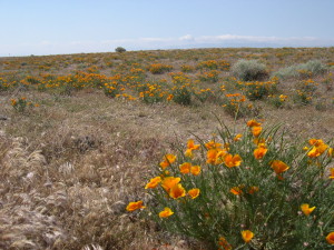
We were rewarded with a nice field of wild poppies just outside of the Reserve. After stopping to take a few pictures we headed out of the Lancaster area on Avenue G towards Barstow.
At 200th Street we ran across this abandoned building once called the High Vista Diner, it seemed very out-of-place, way out here in the middle of what seemed like nowhere. There are some other interesting buildings here but I was more interested in hitting some dirt roads so I figured to head back there some time to check them out. I regret that decision as I have heard that in April of 2008 they bulldozed that diner. I have since learned to always stop and check things out if it catches your interest, it may not be there when you return!
Soon Avenue G turned to dirt and changed to Spirit Mountain Road with 25 miles of wide well-graded dirt until we reached Helendale where we picked up the National Trails Highway or Old Route 66 to Barstow.
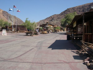
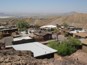
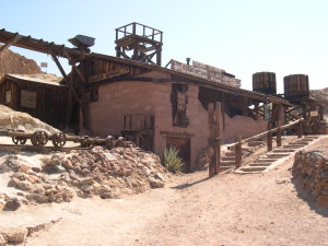
After a good night’s rest at a hotel we are up early to grab breakfast and head over to Calico Ghost Town. Calico is located just three miles from Barstow in the Calico Hills north of the 15 Freeway. Founded in 1881 as a silver boom town it flourished until the mid 1890’s when the price of silver dropped and the area mines were no longer financially viable. Over 500 mines in the area produced silver and borax until around 1907 when the town was finally abandoned.
Walter Knott, who founded Knott’s Berry Farm, purchased the town in 1951 and began restoring and preserving existing buildings and made use of old photographs to rebuild others. Later in 1966 he gave the property over to San Bernardino County who turned it into a County Regional Park. It’s $6 to enter the park and the attractions like the mine tour and railroad ride are extra. In my opinion, you can skip the railroad ride as it is very short and there isn’t too much to see. Although if you have kids with you it would be hard to convince them otherwise.
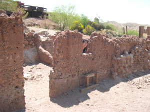
Although it does have a tourist trap, amusement park feel to it, there is some historical value to Calico. The original buildings are remarkably preserved, there is plenty of authentic tools and equipment lying around, and you have the opportunity of entering a real silver mine without the very real risk of getting lost or buried in a collapse. There are a lot of stores with touristy items for sale so if you want an authentic ghost town experience you’ll need to travel to Bodie or Virginia City to get the real deal.
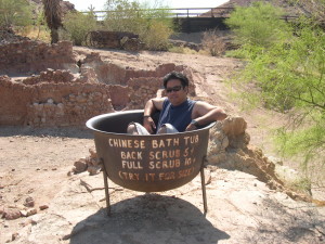
Despite the amusement park ambience, we enjoyed the Chinatown area of Calico if only for the novelty aspect of it. I doubt that this area of town was actually the area where the Chinese community was located. Usually they were located outside of the city in tent encampments. But for the fun of it we tried to envision Cantonese porters and railroad workers from Shanghai relaxing here after a long days work.
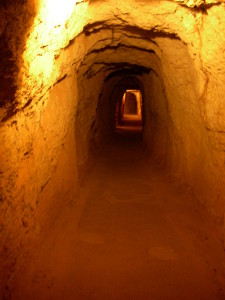
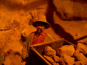
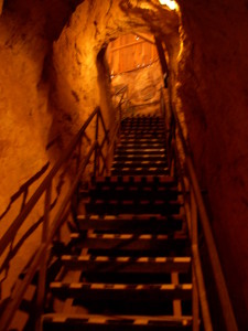
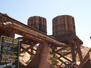
We also enjoyed taking the Maggie’s Mine tour which was interesting. The first part of the mine was very dimly lit, I don’t remember if they suggested bringing a flashlight but I was glad I had more than one on hand. Why did I have more than one flashlight you ask? Several years back we visited the Burro Schmidt Tunnel and the one good flashlight I had overheated and stopped working on us while we were deep in the tunnel. I swore never again would I be unprepared without a backup! They had some nice displays of equipment, minerals, and dioramas that demonstrated how the ore was extracted from the mine. We found the tour interesting and it was a nice break from the hot midday sun.
Maggie Mine
Exploitation of a Chinese Miner
Climb back up to the surface
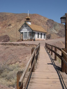
We rambled through the rest of the town and saw the schoolhouse and various buildings with the requisite souvenir shops inside. In the morning when we entered the park it was nearly deserted. We were able to explore the mine and ride the railroad alone but as the day wore on the park got more and more crowded so we made our way back out of the park.
Water tanks and a shot of the water pipe made of wood and wire!
Calico schoolhouse
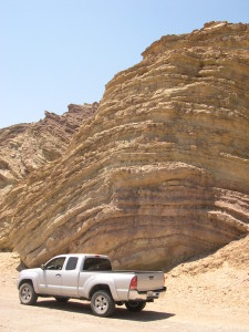
On our way out of the park we noticed some interesting rock formations so we drove over to the overflow parking area for a closer look. I wonder how many people drive right past this formation and don’t even give it a second thought. This entire area is of interest to geologists for the spectacular folds caused by shifting active seimic faults in the area. Seeing these layers of sediment makes my brain start spinning thinking of how much time is represented in these layers and what they could have seen! Also think about the massive amounts of force required to shape these rocks into these gentle bends.
We made our way back down to the small community of Daggett where we drove south of Interstate 40 and found Camp Rock Road. Soon we were on dirt and headed south towards Daggett Wash.
Just outside of Daggett, CA
There really isn’t much information to be found on this 15 mile trail but it is a very remote location headed into the Ord Mountains and provides some excellent opportunities for remote backcountry exploration, camping, and rock climbing. There are old mining sites, cattle ranching operations and most likely ancient habitation sites located in these mountains but since Irene and I weren’t equipped to do much exploration on foot we left those for another time.
Daggett Wash
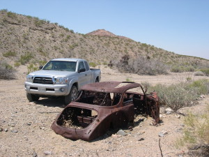
Fancy meeting you here!
When we finally reached the 247 on the other side of the Ords we looked for the Slash X Ranch and stopped by for a bite to eat before headed back home. Built in 1954 for the ranch hands at the Slash X Cattle Ranch this cafe is adjacent to 58,000 acres of the Stoddard Wells OHV Area. On most weekends you will see dirt bikes, quads, and buggies lined up in front to get a cold beer and some bbq before heading back out to play in the dirt.
Overall, I think that the Tacoma’s TRD Offroad suspension and tires held up pretty well but this trail was very mild other than some rocky areas at the beginning of the trail. With the tires aired down to about 20 psi and careful wheel placement, the sharp rocks were not a problem and with the rear locker engaged the sandy areas were not an issue either. Looking back now I am still impressed with this vehicles capabilities as a 2wd truck and it has proven to be a capable backcountry explorer.
Some things to keep in mind if you want to check out this area, this trail is very remote and I would strongly suggest being well prepared to survive for a couple of days if you run into problems. This means having plenty of water, extra gas, food, and some basic tools and equipment. We did not see a single person all day until we got back to paved roads again and so if you break down it may be some time before anyone comes along to lend a hand.
For more pictures from this trip, please click here!